Protoplace Type: Manbuilt
Gizeh Pyramids
Protoplace Type: Manbuilt
Beloy Shamanki
White Shaman
Protoplace Type: Manbuilt
Basse Crémonville
The megalith is located on the edge of the RD 313 southwest of the town of Saint-Etienne-du-Vauvray between the plateau and the Eure a few hundred meters.
The menhir of Lower Cremonville is a block of Senonian limestone 3.30 m high, with an average width of 1.90 m and a thickness of 0.70 m. At the top and 0.50 m from the top, on the side opposite the road, there is a square cavity measuring 0.20 m on the side and 0.05 m deep. A break is also visible at 1 m from the ground, following the transfer of the megalith in 1866.
The monument dates from the Neolithic. It is mentioned for the first time in 1842 when the earthworks of the road along the draw attention to her: “Near the farm Lower Crémonville, hamlet of Saint-Étienne-du-Vauvray, it The road crosses, everyone knew well a large stone, higher than wide, whose limestone, detached from the upper coast, rose in point. […] A search conducted at the foot revealed he ended irregular peak at 1.25 m below the soil surface, and that no object was confined there. It is remarkable only by its direction parallel to the valley and by a shallow opening in the form of a parallelogram which is observed at its summit. The locals confirm what historians think in view of this niche, she had to house a statuette of a Christian saint thus preserving the megalith of destruction.
The continuation of the excavation works of the road is a surprise to the workers when they dig under a huge block of limestone and release many human bones. When they announce their discovery a few days later, additional excavations are undertaken to clear the part of the tomb that was not destroyed by the diggers. They reveal a circular structure about 4.50 m in diameter and composed of three superimposed levels of 0.40 m high each. On each level, skeletons were found: “Each of the body, whose head was resting on a flat stone placed against the circular stone, had his feet in the circle; their arms were lying near the body that filled the cavity. Rubble assembled without masonry separated the corpses between them. Stones 0.15 m thick ensured separation between the intermediate levels. A limestone pavement composed the soil of the tomb. The last level was covered with a sort of rubble vault, itself covered with the enormous block of limestone whose dimensions were, however, smaller than those of the tomb. It had a height of 1.65 m between the ground and the stone that covered it. Only three skeletons are found intact but the meticulous examination of their remains reveals no metal objects. Only a shapeless fragment of a coarse earthen vase and a hatchet species are found.5
This discovery revives interest in the menhir. Its proximity to such a burial could indeed suggest a link between the two.
The construction in 1865 of the railway line connecting Louviers to the line of Rouen endangers the menhir since it is on the route. But the mobilization of the members of the French Society of Archeology is paying off. They rallied the mayor of Louviers André Prétavoine to their cause with the support of his first deputy, Marcel, who had supervised the excavations of the Neolithic tomb. While the road construction works are being completed, the menhir is still in place, “supported by props in the middle of the chalky roadway under construction”. The proceedings with the prefect are successful because he asks for a credit of 400 francs from the General Council of Eure6. Louviers City Council agrees to complete the sum necessary for the translation of the megalith and in the first days of May 1866, the operation is performed by the contractor Huvey, already responsible for the restoration of the Church of Our Lady Louviers7.
“A foreman, 3 workers and 20 labourers worked on it. After digging up, the heavy mass pulled by winches was dragged along a wooden path. The operation was not made smoothly since the block was accidentally broken into two almost equal (one can still follow, one meter from the ground, the irregular trace of the fracture). Finally, the menhir was placed on a bed of limestone and a layer of concrete, in the middle of a field of land offered to the department by the owner of Crémonville-Basse, Mme de Lux. The cost of the transfer, 3 times higher than had been expected, amounted to 1,803 gold francs at the time. The department found this expense so heavy that it renounced to surround the stone with a wall with an inscription, as it had been intended; we contented ourselves with a little hedge of thorns. ”
The megalith occupies the place where was buried the Neolithic burial. It is now classified as historical monuments by decree of June 27, 19272.
Protoplace Type: Manbuilt
Rooster Stone
Instead of one again two menhirs, sandstone. The Rooster is a rectangular prismatic slab 2 m high slightly bent towards the south. The stone is pierced obliquely in its upper part by a hole 7 cm to 10 cm wide and 1 m deep, probably of natural origin. The smaller Hen (1.60 min-height) is located less than 2 m from Le Coq (The Rooster).
According to tradition, the Rooster Stone turns on itself when it hears the cock sing.
South of the two menhirs, lying on the ground, a third slab (6 m by 3 m), also made of sandstone, was recognized as a polisher with a dozen polishing grooves.
Protoplace Type: Manbuilt
Martine Stone
Located about one kilometre south of the city Solre-le-Chateau, in a field to the left of the road that leads to the hamlet of L’Épine, they are menhirs of Landenian sandstone.
They were three originally, but one of them was broken in the nineteenth century to pave the road.
It is said that St. Martin, while a soldier of the Roman legions of Emperor Constantius II, rested on one of these stones, leaving the imprint of his back. True artisan of the rural apostolate in northern Gaul, the fourth century, St. Martin was indeed a great destroyer of pagan temples and converted many Druidic monuments into altars of Christianity.
The popular faith followed his teaching and did as he did, even in places where he had not passed. Thus the legend of Saint Martin remains attached, in France, to a large number of fountains or megaliths.
The Martines stones form a perfect alignment with the Dessus-Bise stone of Sars-Poteries and Pierre-Qui-Tourne from Sivry (Belgium).
Protoplace Type: Manbuilt
Chavin De Huantar
In Chavin de Huantar’s ruinen bin ich in jedes loch reingekrochen das ich reinkam. Bei den Wasserkanälen bin ich nicht an dessen enden gekommen.
Einerr währe sehr interessant weil er licht hat. Die kabel sind zwar gekappt, gehen aber weiter als ich gegangen bin. Kurvig und immer niedriger wird er. Es hatte feldermäuse und plötzlich Wasser am Boden, etwa 10cm tief (Bis dahin wo ich ging).
Der gang ist ringsum gemauert, geht zunächst 2 meter in die tiefe dann 180 Grad um die ecke um dann weiter in die tiefe zu fallen. Ich kehrte nach ca. 40 bis 60 meter um. Schätzungsweise befand ich mich in freute al Hauptportal der Pyramide, ca. 10 meter davon entfernt Richtung Main Plaza, etwa 5 meter unter dem jetzigen Boden. Der “TUNNEL” Pfeil in der mappe neben an zeigt wo der gang approximativ hinging.
Es gab keinen Luftzug, was heisst dass es höchstwahrscheinlich kein 2er Ausgang gibt., zumindest kein direkter. Ich bereue dass ich nicht weiter bin, aber ehrlich, ich hatte angst.
Der zweite grosse gang geht diagonal unter der Plaza Richtung Tempel. Die Fledermäuse verjagten mich auch hier. Der gang hat eine Verzweigung, der mit ästen verschlossen ist, so ein “Indianerzaun”.
Der dritte gang, an der Südseite der Pyramide war mit der zeit so klein dass ich kriechen musste, bis ich nicht mehr drehen konnte ging ich weiter, da sah ich dass er eine Biegung machte.
Also für genau was waren diese Gänge? Für Wasser, sagen die Guides.
Aber wieso erbauten sie diese dann nicht in gerader Richtung, sondern mit x sinnlosen kurven? Und wieso manchmal mannshohe, dann wieder kein Deut breit?
Es ist ein Rätsel.
Ich muss ein Roboter bauen mit dem ich das kleinste erforschen kann…
Halt! Sind Fledermäuse nicht ein Zeichen für Luft und platz? Das Gebäude ist jedenfalls zur hälfte verschüttet, also es schaut nur die spitze der Pyramide raus. Das beweist auch der gang der im “Middle part” sichtbar ist (505X50 gang dann in die tiefe), der Unterarm breite 3 Sekunden in die tiefe fällt!
9.1m/s * 3s * 0.5KG = 13,65 meter minimale tiefe!

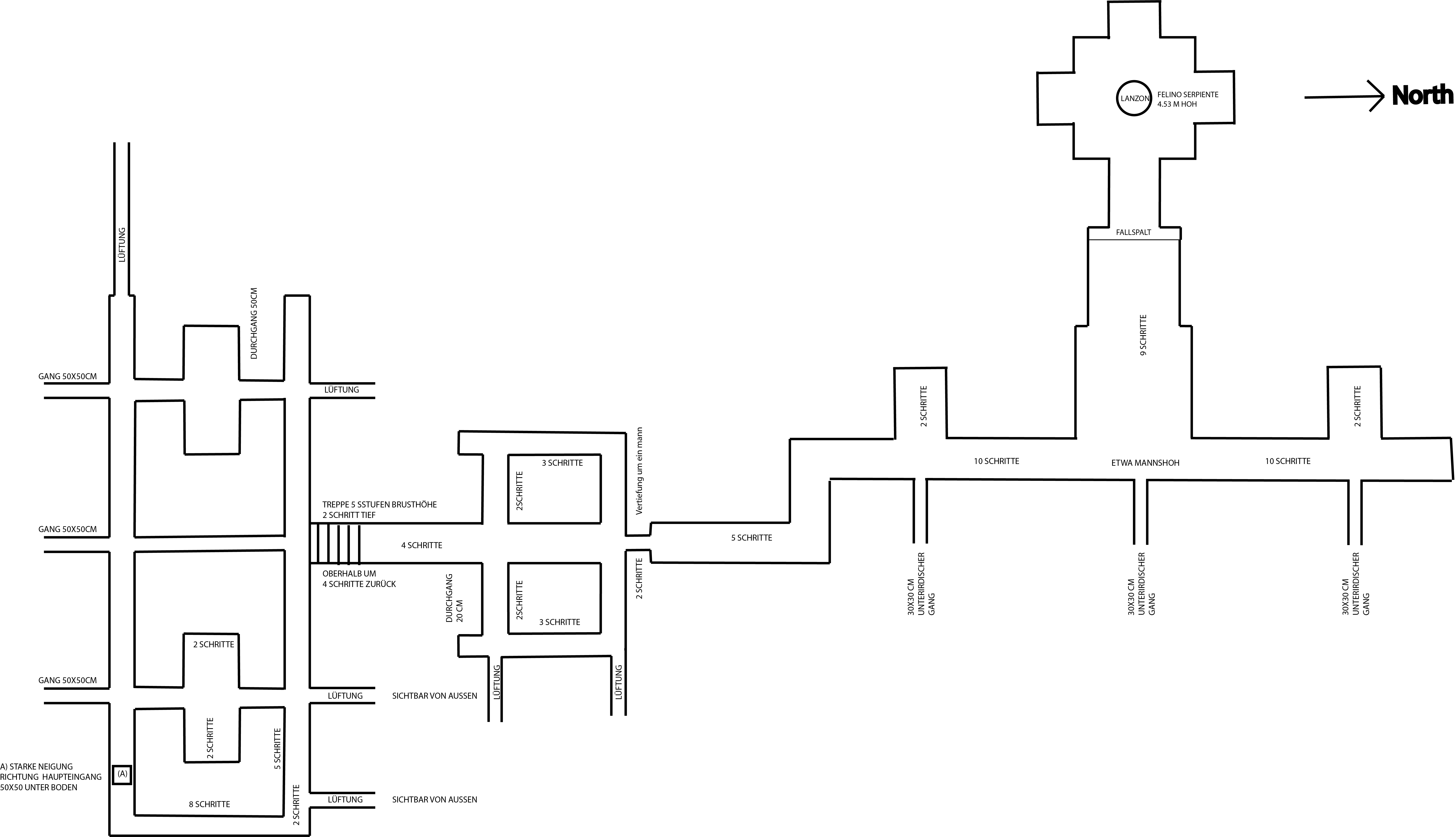
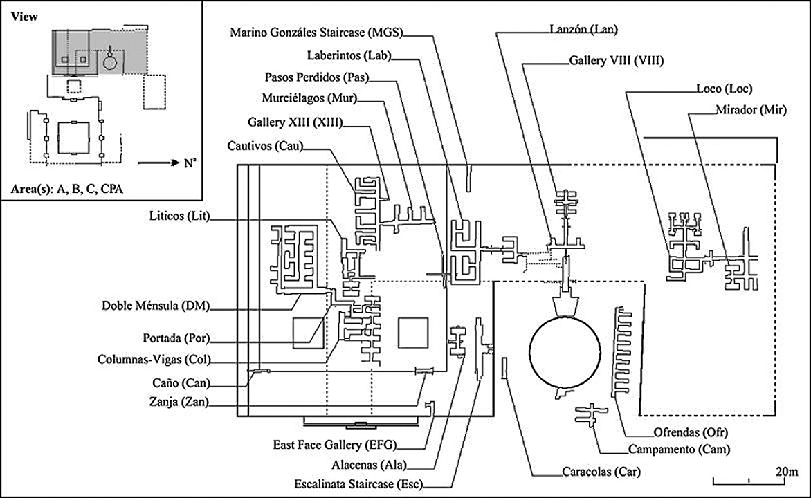
Hier unten noch ein paar detail ansichten der gänge in der pyramide und wo der lanzon gefunden wurde. Auch ein Detail plan der Plaza und des diagonalen Ganges….


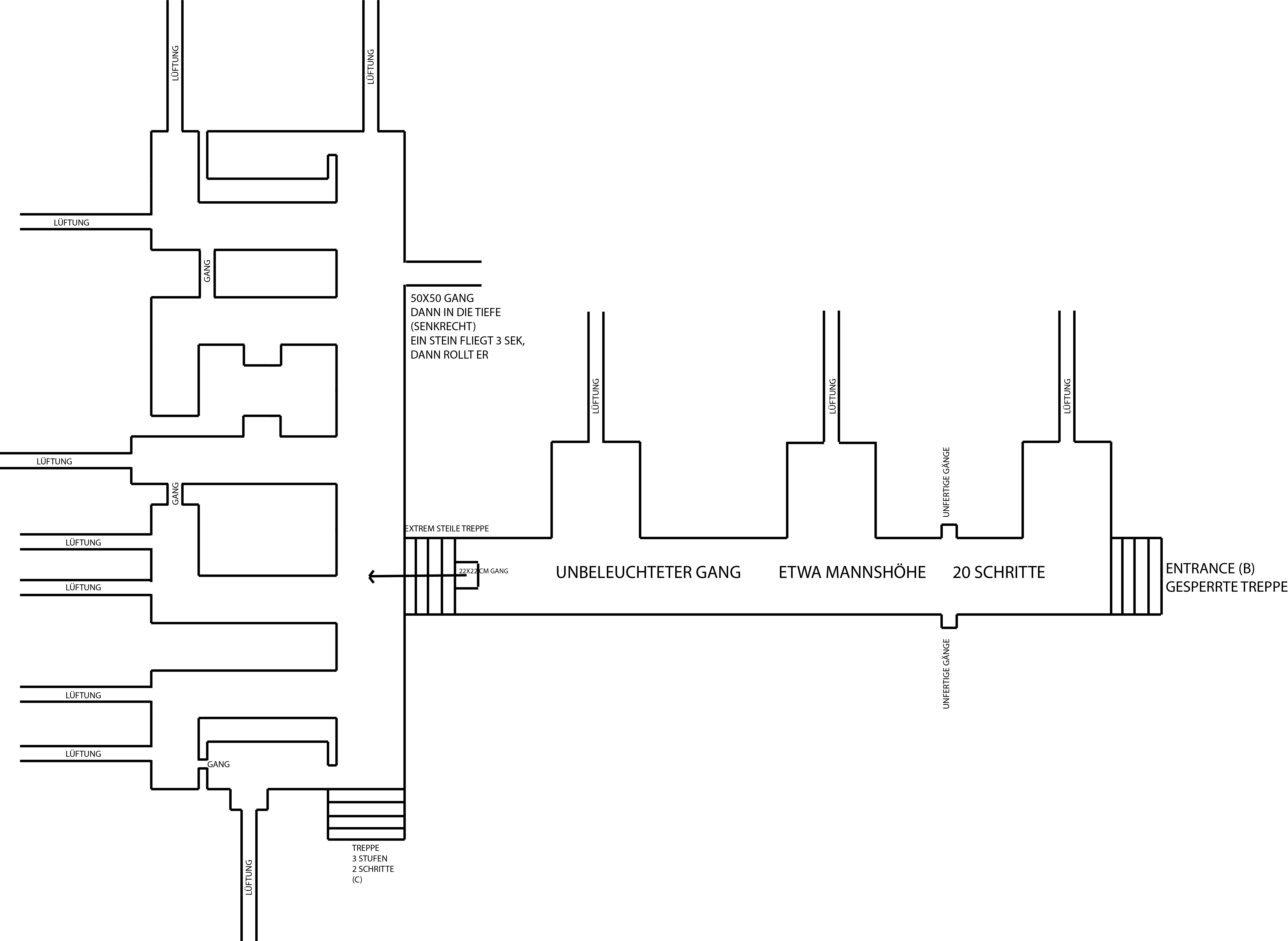
Ich hab noch ne pfunzle gekauft damit ich die unbeleuchtete Gänge erforschen konnte – was in den obigen detail plänen dann ersichtlich ist. Zumindest soweit ich konnte und getraute.
Was interessant ist, in steilen (90grad) Felswänden ringsherum Chavin, hat es Löcher und Pfade – zumindest sieht es so aus aus der ferne.
Richtung Norden, talabwärts, gibt es einen grossen Felsbrocken der wie einen versteckten Eingang aussieht. Die zeit reichte nicht um dahin zu gehen. Und, es war eh verbotene zone.
Es muss auch jene kleinere tempelchen geben in der umbegbung …
Leider ist die gesamte Tempelanlage ziemliche Ruine…


Die cabezas clavas (welche überall in der Pyramide steckten und auch noch sind), haben verschiedene physiognomische formen, von Adler bis Neger Nase, etc. Aber alle haben Jaguarzähne und zwar immer die oberen 2 hinter den Unterzähnen. Manchmal haben sie auch nur 2 obere zähne. Auch die augen variierten, von quadratisch bis kugelrund. Manchmal haben sie zusätzlich dinge unter der Nase zum Beispiel wie in den Zeichnungen nebenan.
Oben auf dem kopf haben sie entweder ein loch, oder ein zapfen. Manchmal schneiden sie grimmassen, Puma köpfe, Mischungen, Menschenköpfe.
Die stele (Lanzon) stand anscheinend in einer Vertiefung in form eines Christenkreuzes, ich weiss nicht ob das echt ist, da leider der Lanzon räum abgesperrt ist, was ich sah war wie eine Chakana, deshalb ist das auch so in meinem plan, es könnte aber seine dass es eben ein Christenkreuz mit sehr kleinen ecken Aussparungen war, das es dann wie eine chakana aussehen lässt wenn man nur von aussen reinschauen kann. Ich hab selbst noch ne Zeichnung wo genau diese Mischung aus chakana und Christenkreuz sichtbar ist – also ist mein “The entire Complex” plan eventuell falsch – dennoch gibts auch plane die es wie hier (siehe “gallery VIII”) aussehen lassen…


